Aircraft Spruce & Specialty Co.

- Photo may represent series and not specific product
- SHARE


 FREE Shipping
- JUMP TO
- Overview
- Reviews
- Q&A
- View in Catalog
Overview
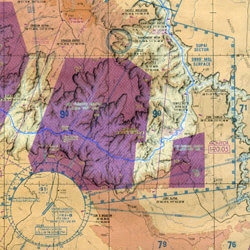
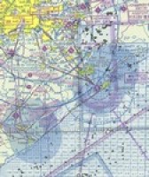
Grand Canyon VFR Aeronautical Chart covers the Grand Canyon National Park area and is designed to promote aviation safety and facilitate VFR navigation in this popular flight area. The chart contains aeronautical information for the general aviation VFR pilots on the front side, and commercial VFR air tour operations on the backside. Special features on both sides include:
Scale 1:250,000 |
WARNING: Cancer and Reproductive Harm - www.P65Warnings.ca.gov. |


Reviews
Delivered as advertised, I was notified of delayed delivery due to getting updated maps. thank you
Grand Canyon VFR Aeronautical
Q&A
Please note, Aircraft Spruce ®'s personnel are not certified aircraft mechanics and can only provide general support and ideas, which should not be relied upon or implemented in lieu of consulting an A&P or other qualified technician. Aircraft Spruce ® assumes no responsibility or liability for any issue or problem which may arise from any repair, modification or other work done from this knowledge base. Any product eligibility information provided here is based on general application guides and we recommend always referring to your specific aircraft parts manual, the parts manufacturer or consulting with a qualified mechanic.