Aircraft Spruce & Specialty Co.


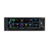

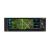


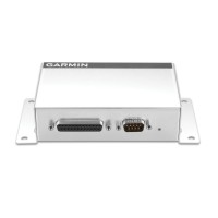
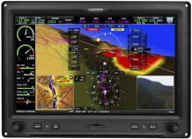
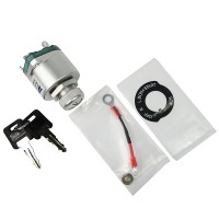
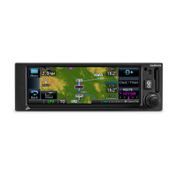
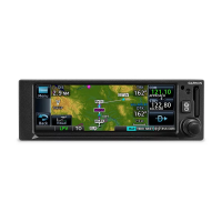
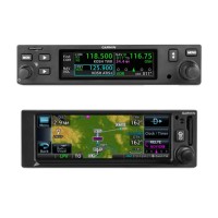
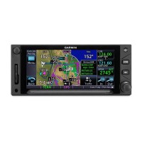
Garmin GPS 175 GPS Navigator With GA 35 GPS Antenna Kit With Wire Pigtail For Experimental Aircraft
 FREE Shipping
Overview
LPV Approaches, Priced for Your Aircraft
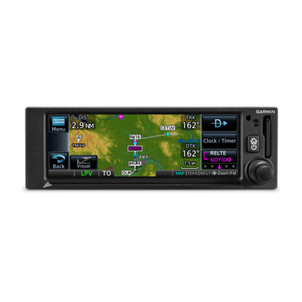
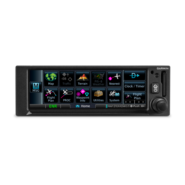
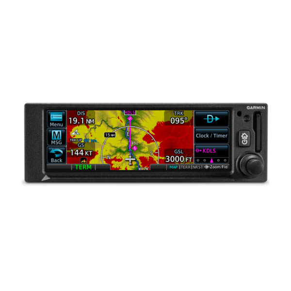
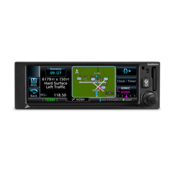
Perfect TouchThe moment you power up GPS 175, youll see a familiar Garmin homepage on the 4.8 display, which puts the most important functions within only a few touches. Navigate to dedicated pages for the moving map, terrain, nearest airports, flight plan, procedures, waypoint information, utilities and more. With shortcuts available to the flight plan and Direct-to functions on almost every page, navigation features are usually just a tap away. Use your finger to pan and zoom on any map, traffic and terrain page. Enter waypoint data with the on-screen keyboard. And touch the home button to get you back to the main page at any time.For added control stability in flight, a shelf across the lower edge of the display serves to steady your hand in smooth and turbulent flight conditions. And if you prefer traditional controls, the concentric knobs provide yet another way to control many of the GPS 175 navigators functions. 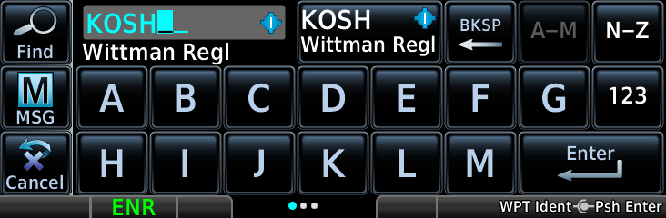 Intuitive NavigationWith GPS 175, building and modifying flight plans is simple. As you enter waypoints, our FastFind feature automatically begins searching for the nearest identifier as soon as you start typing, so in most situations a press or 2 reveals just what you were thinking. You can also create holds, insert Victor airways and corresponding exit options, and add departures, arrivals and instrument/visual approach procedures. Additionally, you can edit your route using the map screen; a handy "rubber band" feature lets you grab any leg of your flight plan route and move it to accommodate a deviation or ATC amendment to your flight plan.A variety of dynamically drawn and displayed maps provide situational awareness and context to the flight plan by highlighting visual reporting points, navaids, SafeTaxi® diagrams and hazards such as obstacles, power lines and terrain. Plus, the Smart Airspace feature automatically highlights airspace close to your current altitude and de-emphasizes airspace away from the current altitude. 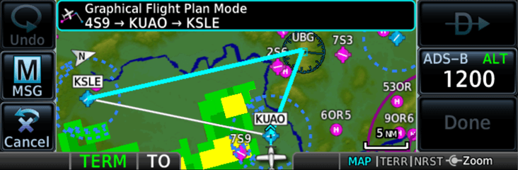 Advanced Approach to IFRThe SBAS/WAAS-certified GPS receiver can allow you to fly GPS-guided LPV glidepath instrument approaches down to as low as 200, greatly expanding your operational capability. You can also access newer lateral performance (LP) and all area navigation (RNAV) approaches. Precise course deviation and roll steering outputs can be coupled to our GFC 500 and GFC 600 autopilots as well as select third-party autopilots so that IFR flight procedures such as holds, NextGen radius-to-fix (RF) legs and missed approaches may be flown automatically. In addition, the GPS 175 navigator lets you create and execute custom holding patterns over an existing waypoint or user-defined waypoint.Plus, when operating in VFR conditions, GPS 175 can provide advisory vertical approach guidance based on a published glidepath angle or a 3-degree approach glideslope from the runway threshold, while considering terrain and obstacle clearance. With this advisory guidance, youre able to fly more consistent, precise vertical glidepaths into a variety of airfields. 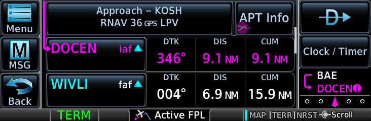 Add ADS-B Traffic and WeatherWhen paired with dual-link Garmin ADS-B solutions, such as our GTX 345 series transponder or GDL® 88 universal access transceiver, GPS 175 can display ADS-B traffic targets as well as subscription-free ADS-B weather data in the U.S. The ADS-B weather link provides in-flight access to animated NEXRAD imagery, METARs, TAFs, winds and temperatures aloft, PIREPs, NOTAMs and more.When equipped with a compatible ADS-B solution, visual alerts help you recognize and avoid potential conflicts in busy airspace. Our patented TargetTrend relative motion technology offers a faster, more intuitive way to judge the direction and closure rate of intruding targets in relation to your aircrafts position. For example, if traffic is ahead of you and traveling along the same track but at a slower rate, the motion vector would point opposite of its indicated direction of flight to show you are overtaking the traffic. And, at the start or end of each flight, TerminalTraffic technology provides the most comprehensive picture of ADS-B equipped aircraft and ground vehicles in the airport environment. ADS-B equipped aircraft in-flight are easily distinguished from ground vehicles and taxiing aircraft, which are displayed using distinct colors and symbols. All information is presented on a simple, easy-to-understand SafeTaxi diagram with reference to runways, taxiways, hangar locations and more. 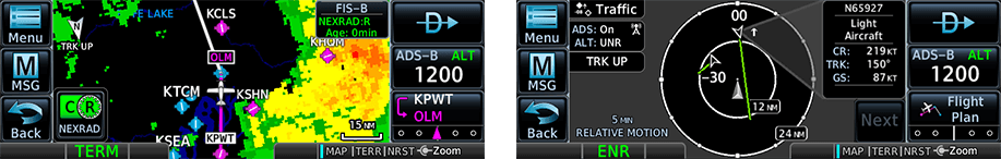 Cockpit IntegrationThe GPS 175 navigator interfaces with a variety of Garmin flight displays, including G3X Touch (experimental and certified), G5 (experimental and certified), G500/G600, G500 TXi/G600 TXi as well as select third-party displays¹. Plus, its also compatible with many legacy, composite-input based CDIs allowing you to keep your existing CDI and have an easier, more cost-effective installation¹.And for even more work-saving convenience, you can use the built-in Connext technology to stream information between GPS 175 and compatible Garmin portables and mobile devices running the Garmin Pilot or FltPlan Go apps. You can create flight plans at home and upload them at the airport. And you can stream GPS data and backup attitude information (from the built-in AHRS) to your mobile device or Garmin portable, making them even more useful cockpit companions. Better still, you can also share ADS-B traffic and weather information if youre equipped with a compatible ADS-B solution. Plus, our optional Flight Stream 510 installs in the memory card slot of GPS 175 to enable our Database Concierge database transfer and management capabilities via our Connext gateway. At home, you can download selected databases onto your mobile device by using the Garmin Pilot app. Then, once you get to the airport, Flight Stream 510 will automatically establish a wireless connection to the Garmin Pilot app and upload the databases from your device to your GPS 175 in minutes.  |
WARNING: Cancer and Reproductive Harm - www.P65Warnings.ca.gov. |
Specifications
- TSO applicability: C146e Class 3; C157b Category 1; C165a; C195b Category B1, B3, B5, B7
- Display size: 4.8" (122.5 mm) diagonal
- Display resolution: 732 pixels (W) x 240 pixels (H)
- Unit bezel height: 2.02" (51.0 mm)
- Unit bezel width: 6.25" (159.0 mm)
- Unit depth with connectors: 6.58" (167 mm) (measured from face of aircraft panel to rear of connector backshells)
- Unit weight: 1.3 lbs (0.6 kg)
- Maximum altitude: 35,000 ft
- Input voltage range: 9 VDC - 33 VDC
- Maximum display brightness: 260 fL
- Operating temperature range: -20° C to 55° C (-4° F to 131° F)
- Bluetooth version: 4.2
- Number of GPS channels: 15 (12 GPS and 3 GPS/WAAS/SBAS)
- LAT/LON position accuracy: <1.25 meter RMS horizontal, < 2 meter vertical, with WAAS
- Maximum velocity: 1,000 knots (above 60,000 feet)
- Position update Interval: 0.2 sec (5 Hz)
Physical and Performance
Interfaces
| Interface | Manufacturer | Model |
|---|---|---|
| Autopilots | Honeywell (Bendix/King) | KAP 100/140/150, KFC 150/200/250 |
| KFC 225/275/325 | ||
| Century | I/II/III/IV, 21/31/41, 2000, Triden | |
| AK 1081 [1] | ||
| S-TEC | System 20/30/40/50/55/60-2/60 PSS/65 | |
| System 55X | ||
| ST-901 [1] | ||
| Cessna | 300B/400B/800B | |
| 300 IFCS/400 IFCS | ||
| Garmin | GFC 500 | |
| GFC 600 | ||
| Navigation Indicators | Garmin | GI 106/106B (IFR) |
| GI 102/102A (VFR) | ||
| Honeywell (Bendix/King) | KI 204/209/209A (IFR) | |
| KI 203/208/208A (VFR) | ||
| KI 206/209A/525A,KPI 552/552B/553/553A/553B (IFR) | ||
| KI 202/208A (VFR) | ||
| ARC (Cessna) | IN-386A, IN-481AC (IFR) | |
| IN-385AC (VFR) | ||
| Century | NSD 360A, NSD 1000 (IFR) | |
| Collins | 331A-6P, PN-101, IND-351D (IFR) | |
| S-Tec | ST 180 (IFR) | |
| Mid Continent | MD222-406, MD200-306, MD200-307 (IFR) | |
| MD222-402, MD200-302, MD200-303 (VFR) | ||
| Narco | VOA 5/9/50M (IFR) | |
| VOA 4/8 (VFR) | ||
| EFIS Displays | Aspen | EFD 1000/500 |
| Garmin | G500/G600 | |
| TXi Series | ||
| G5 (ADI) | ||
| G3X Touch | ||
| EHSI Displays | Garmin | G5 (HSI) |
| Sandel | SN 3308 | |
| SN 3500/4500 | ||
| Heading Reference Sources | Aspen | EFD 1000 |
| Garmin | GAD 42 | |
| G500/G600 | ||
| TXi Series | ||
| Sandel | SN3500 | |
| SN3308 | ||
| Multifunction Displays | Garmin | GMX 200 |
| MX20 | ||
| Datalinks | Garmin | GDL 82 |
| GDL 88/88D | ||
| Transponders | Garmin | GTX 327 |
| GTX 328 | ||
| GTX 330/330D | ||
| GTX 330/330D w/ES | ||
| GTX 335 | ||
| GTX 345 |


Reviews
The G-175 is fantastic once you get past the Garmin secret society. I bought it on Wednesday for my RV-8A that I had built many years ago. Finally pulled the trigger on a TSOs GPS because Dynon had not come out with one yet. The G-175 fit perfectly in my panel under my 10 inch Dynon. In order to integrate with the Dynon do not use the Garmin Arinc 429. It will knock out the Dynon screen. You must use the Dynon 429. I also ordered the 4 foot pig tail. While the outer wire was labeled, the inside which had as many as 3 wires had no labels. Trying to get the information from Garmin was like trying to get the nuclear launch codes. Never did get a response with the info. After a few tries got it right. Also on Wednesday when I ordered the G-175 I went looking for the install manual. Called Garmin and was told I needed the serial number for the unit or the receipt. Sent that in and never got a response. Called again on Friday when the unit came in and they said installer would have it. Told them I was an experimental guy and needed the manual and had been trying since Wednesday to get it. The Garmin rep felt my pain and emailed it to me within minutes. You will get a plethora of cards with various codes on them. Most are meaningless except the free one time update. There is no card with your unit serial number or system ID. Before installing write down serial number. First time you turn it on get the system ID from the info pages on the screen. You will need these 2 things, Garmin has no idea what your system ID number is. Took 4 different computers and several hours on the phone with Garmin to get the down load working. This was my experience, yours may vary, even with all the hassle very glad to be able to shoot WAAS approaches. Once you get past the pain of the install you will like the unit very much. Unit gets a 5 star, Garmin gets a 1 star, so average is 3.